


Chapter I – Scope and interpretation
Division II – Interpretation
Section 2
In this Regulation,
“abutment” means the end support of a bridge that holds the approach fill. Abutments are made of reinforced concrete, wood or steel caissons or a combination of stakes crowned by a portal cap beam; (culée)
“accommodation centre” means a group of commercial buildings laid out on an area in a single block and having an accommodation capacity of at least 15 persons per day; (établissement d’hébergement)
“aggregated cut block” means a territory situated in a management unit in which total cutting areas with or without recent natural disturbance zones are concentrated. The aggregated cut blocks must vary in shape and have an area less than or equal to 150 km2. Despite the foregoing, they may be larger in the case of plans for the protection of woodland caribou, woodland ecotype; (agglomération de coupes)
“archaeological sector” means a place where archaeological sites are concentrated and the surrounding grounds whose geographical characteristics and situation offer an archaeological potential; (secteur archéologique)
“archaeological site” means any site indicating prehistoric or historic human occupation and registered in the Register of the domain of the State referred to in section 26 of the Act respecting the lands in the domain of the State  (chapter T-8.1); (site archéologique)
“bank” or “shore” means the lateral part of variable steepness of the bed of a watercourse or lake that may be submerged without the water overflowing. The upper limit of the bank is located at the top of the angle of repose located at the lower limit of emerged grass or, if there is no such grass, at the low limit of shrubs. In the absence of emerged grass and shrubs, the top of the angle of repose corresponds to the level of the bankfull discharge; (berge) 
1
Explanations
How is the upper limit of the bank of a lake or watercourse identified?
The upper limit of the bank is located at the top of the angle of repose of a lake or watercourse bed, located at the low limit of emerged grass or, if there is no such grass, at the low limit of shrubs. In the absence of emerged grass and shrubs, the top of the angle of repose corresponds to the level of the bankfull discharge.
The level of the bankfull discharge is usually determined from physical indicators, the best of which is the beginning of the flood-risk area (or plain) – in other words, the beginning of the relatively flat stretch of land that is submerged when the watercourse or lake overflows from its bed. Overflow occurs in spring but can also occur during heavy rain. There is often an abrupt change in the slope between the bank and the flood-risk plain. It is important not to confuse this abrupt change with the one found at the mean water or low flow level. Other indicators can also be used to determine the level of the bankfull discharge, including the top of a bank eaten away by erosion, vegetation, a change in slope substrate particle size, and so on.

Figure 2A Upper limit of the bank and overflow above the level of the bankfull discharge
“bear den” means a site where bears hibernate. The bear dens that are to be protected are those indicated in the numeric information layers used for forest planning; (tanière d’ours)
“bed of a watercourse” means a natural depression in the ground occupied by a permanent or intermittent watercourse, comprising the bottom and the banks. The bed of the watercourse is free of vegetation other than aquatic plants, if any. It shows signs or traces of waterflow, whether underground or not; (lit d’un cours d’eau)
2
Additional information
The waterflow characterization key is used to differentiate waterflow in the watercourse bed from waterflow due to natural drainage.


“block cutting” means an area of total cutting or a group of areas of total cutting carried out in a given territory so as to preserve, within the limits of the block cutting harvest site, a residual forest having the characteristics set out in section 139; (coupe en mosaïque)
“block cutting harvest site” means a territory delimited by all the cutting areas for block cutting, with a distance of less than 2 km between the areas, and by a strip of land 2 km wide surrounding the whole site; (chantier de récolte en mosaïque)
3

Figure 2B Diagram showing a block cutting harvest site
“boat access route to trapping grounds” means a route that comprises rivers, lakes and portage trails leading to trapping grounds and recognized by a Native community that includes members who use it every year. The boat access routes to trapping grounds that are to be protected are those indicated in the numeric information layers used for forest planning; (parcours d’accès en embarcation aux terrains de piégeage)
“bridge” means a structure not built under embankments including abutments, sometimes piers, a deck and stabilizing materials and that allows a road to cross an obstacle, such as a watercourse; (pont)
“burial site” means a place where the body of a deceased person is interred. The burial sites that are to be protected are those indicated in the numeric information layers used for forest planning; (site de sépulture)
“canoe-kayak-camping course” means a marked route to go down watercourses in a canoe or kayak that includes rivers and lakes along the banks and shores of which a number of wilderness campgrounds are located, and often portage trails that are developed and maintained by a government body, a municipality, the Fédération québécoise du canot et du kayak or a club affiliated with that federation. The canoe-kayak-camping courses that are to be protected are those indicated in the numeric information layers used for forest planning; (parcours de canot-kayak-camping)
“caribou calving area north of the 52nd parallel” means a caribou calving area north of the 52nd parallel within the meaning of section 1 of the Regulation respecting wildlife habitats ; (aire de mise bas du caribou au nord du 52e parallele)
“cliff inhabited by a colony of birds” means a cliff inhabited by a colony of birds within the meaning of section 1 of the Regulation respecting wildlife habitats ; (falaise habitée par une colonie d’oiseaux)
“commercial species” means a tree species referred to in Part A or Part B of Schedule 2; (essence commerciale)
“complementary vacation site” means a site comprising at least 3 vacation lots, at the rate of at least 1 lot per 0.8 ha. Complementary vacation sites are developed to complete the development of vacation sites on the shores of a lake where the biophysical characteristics of the environment no longer make it possible to comply with the installation criteria for a grouped vacation site; (site de villégiature complémentaire)
4
Explanations
Complementary vacation sites are developed to complete the development of vacation sites on the shores of a lake where the biophysical characteristics of the environment no longer make it possible to comply with the installation criteria for a grouped vacation site. The area of a complementary vacation site must comprise at least three vacation lots, and there must be at least one lot per 0.8 ha. The area of a complementary vacation site with only three vacation lots must therefore be no more than 2.4 ha, to meet the minimum density requirement of one lot per 0.8 ha.

Figure 2C Diagram showing a complementary vacation site, an isolated vacation site and a grouped vacation site
“concentrated network of hiking trails” means a site criss-crossed by hiking trails developed for recreational purposes, except trails intended for motorized all-terrain vehicles, at a density equal to or greater than 2.5 km per square kilometer; (réseau dense de sentiers de randonnée)
5

Figure 2D Peripheral circuit of a concentrated network of hiking trails, an interregional hiking trail and a concentrated network of hiking trails
“continuous forest cover” means a forest cover with a density of at least 25%, characterized by a relatively uniform space between its stems and not having any patch greater than the size of the dominant trees forming it; (couvert forestier continu)
6
Additional information
The stems used to calculate continuous forest cover density must be 3 metres or more in height.
“culvert” means a structure built under embankments including an arch or at least a conduit and stabilizing materials and that allows a road to cross an obstacle, such as a watercourse; (ponceau)
“cutting area” means an area in a single block where a single type of cut is used, during a single harvest year, comprised in a development unit or in another forest of the domain of the State; (aire de coupe)
7
Additional information
To be considered in a single block, the entire area, included in a management unit or another forest unit in the domain of the State, must be the same type of cut, during the same harvest year.
Thus, a forest strip of 30 m or more, crossing the area mentioned above, has the effect of dividing the latter into two separate harvested areas, i.e. two cutting areas. It can be the result of a forest strip, subject or not to a partial harvest, kept on each side of a landscaped path or a path identified as a road corridor, for example. A wooded edge of 20 m (therefore 40 m in total when there is a harvest on both sides of the watercourse) kept along a permanent watercourse does not have the effect of dividing a cutting area into two separate areas.
However, a path that crosses such an area does not have this effect. The area remains in one piece and is therefore considered to be a single cutting area.
“developed campground” means a site developed for the sojourn of campers, accessible by road and having service areas such as shelters, toilets and parking lots. Each camping site or group of sites including no more than 20 camping site is supplied with running water or electric power by a private or public distribution network offered by the lessor of camping space; (camping aménagé)
“developed trail” means a trail, other than a trail intended for motorized all-terrain vehicles, for which amounts were invested by the managers of an outfitting operation, a controlled zone or a wildlife sanctuary, with a view to offering services to all the users of those territories; (sentier aménagé)
8
Explanations
A developed trail is a trail for which amounts were invested to perform work (e.g. subsidized work or work authorized by a forestry permit) with a view to offering services to the users of an outfitting operation, a controlled zone or a wildlife sanctuary. The services may involve hiking, horse riding, cross-country skiing, snowshoeing, dog sledding, small game hunting and portage, as well as access to a managed body of water or another service offered in the area concerned. In this Regulation, a trail intended for motorized all-terrain vehicles is not considered to be a developed trail.
“dock site with a boat ramp” means a public site with the facilities required to facilitate the coming alongside and the launching of pleasure boats, as well as its service areas, such as shelters, toilets and parking lots; (site de quai avec rampe de mise à l’eau)
“downhill skiing station” means a site developed for the practice of downhill skiing and its service areas, such as shelters, toilets and parking lots; (station de ski alpin)
“dwelling” means any building intended for occupancy by human beings and provided with a water supply system and a waste water disposal system connected to the ground; (habitation)
“ecological or nature interpretation centre” means a site consisting of trails developed for educational purposes in connection with ecology or for purposes of discovering nature and service areas such as shelters, toilets and parking lots; (centre d’écologie ou de découverte de la nature)
“fish habitat” means a fish habitat within the meaning of section 1 of the Regulation respecting wildlife habitats ;
“fish hatchery” means a site comprising the facilities and equipment required for the raising and breeding of fish with a view to seeding the lakes and watercourses of a region; (station piscicole)
“forest camp” means a place where dwellings and facilities are grouped mainly for the use of workers assigned to forest development activities authorized under a forest development plan; (camp forestier)
9
Additional information
Where the workers who perform forest development work live in a camp, the camp may, at the same time, host people practising other activities (e.g. hunting, fishing).
“forest cover density” means the relative ground cover by the projection of all the living branches of trees 7 m tall or higher; (densité du couvert forestier)
“forest development activity” means a forest development activity within the meaning of paragraph 1 of section 4 of the Sustainable Forest Development Act (chapter A-18.1); however, for the purposes of sections 3, 5, 19 to 22, 47, 50, 52, 54, 55, 57 and 59, it does not include the repair, maintenance and closure of forest roads or the control of fires, insect epidemics and cryptogamic diseases; (activité d’aménagement forestier)
10
Explanations
Subsection 1 of section 4 of the Sustainable Forest Development Act defines the term “forest development activity” as follows:
an activity related to timber felling and harvesting, the operation of a sugar bush, the construction, improvement, repair, maintenance or closure of infrastructures, the carrying out of sylvicultural treatments, including reforestation and the use of fire, fire protection, the suppression of insect epidemics, cryptogamic diseases and competing vegetation, and all similar activities that tangibly affect forest resources.
However, the definition of “forest development activity” in section 2 of this Regulation means that the standards set out in sections 3, 5, 19 à 22, 47, 50, 52, 54, 55, 57 and 59 do not apply to the repair, maintenance and decommissioning of roads in the forest, fire protection or the suppression of insect epidemics and cryptogamic diseases.
Additional information
The activities that precede commercial or non-commercial sylvicultural treatments are forest development activities. These can include surveys to identify land in need of sylviculture work, delimiting cut blocks, and carrying out intervention inventories and timber marking.
“forest operations zone” means a maximum area of 250 ha, not necessarily in a single block, that is the subject of a single sylvicultural treatment during a single harvest year, comprised in a single development unit or other forest in the domain of the State; (secteur d’intervention)
“forest stand” means a forest area of a single block of at least 30 km2, of which a minimum of 70% of the productive forest area is constituted of timber stands 7 m or higher; (massif forestier)
“geotextile membrane” means a permeable textile, needle punched and nonwoven, having a minimum tensile strength of 1,000 newtons and interstices smaller than 150 micrometres; (membrane géotextile)
“grouped vacation site” means a site comprising at least 5 vacation lots, at the rate of at least 1 lot per 0.8 ha; (site de villégiature regroupé)
11
Explanations
The area of a grouped vacation site must comprise at least five vacation lots, at the rate of at least one lot per 0.8 ha.
The area of a grouped vacation site with only five vacation lots must therefore be no more than 4 ha. to achieve the minimum required density of one lot per 0.8 ha.
Figure 2C Diagram showing a complementary vacation site, an isolated vacation site and a grouped vacation site
“harvest year” means the period comprised between 1 April of a year and 31 March of the following year; (année de récolte)
“heritage cultural landscape” means a land area recognized by a community for its remarkable landscape features, which are the result of the interaction of natural and human factors and are worth preserving and, if applicable, enhancing because of their historical or emblematic interest, or their value as a source of identity, within the meaning of section 2 of the Cultural Heritage Act (chapter P-9.002); (paysage culturel patrimonial)
“heritage site” means a place, a group of immovables or, in the case of a heritage site referred to in section 58 of the Cultural Heritage Act (chapter P-9.002), a land area that is of interest for its archaeological, architectural, artistic, emblematic, ethnological, historical, identity, landscape, scientific, urbanistic or technological value, within the meaning of section 2 of that Act; (site patrimonial)
“heronry” means a heronry within the meaning of section 1 of the Regulation respecting wildlife habitats ; (héronnière)
“holder of a forestry permit” means the holder of a forestry permit referred to in section 73 of the Sustainable Forest Development Act (chapter A-18.1) or the third person to whom the permit holder entrusted the performance of the work authorized by the permit; (titulaire d’un permis d’intervention)
“improvement work on a road, bridge or culvert” means work performed to improve a road or road segment, including the bridges and culverts, in relation to the condition it was in at the time of its construction or latest improvement, as the case may be. In the case of a road, the work includes the following, among other things: operations to upgrade a road’s class, particularly by making it wider; course correction; the reduction of slopes and the addition of safety devices such as safety slides. In the case of a bridge or culvert, the work includes, among other things: the replacement of the structure by a different structure, such as replacing a culvert with a conduit by a culvert with an arch, and alterations to the structure of a bridge to improve its bearing capacity; (travaux d’amélioration d’un chemin, d’un pont ou d’un ponceau)
12
Additional information
As indicated in the work type definitions, the condition of the road prior to the work is the reference for determining the type of work being performed.
In addition to the work mentioned in the definition, the following work is also considered to improve roads, and is subject to authorization:
- the replacement of a culvert comprising a conduit with two conduits in parallel (or vice versa);
- the graveling of a path that was not at the time of its construction;
- the asphalting, placing of recycled asphalt, concreting of a road that was not paved at the time of its construction or the final removal of asphalt or concrete from the road surface;
- the correction of a curve or road section;
- the addition of safety slides or the placement of speed bumps or median strips.
In cases where the work is to upgrade the road class, it must have the effect of upgrading the road characteristics, such as width and shoulders, to those of the higher class of road. If the work ensures that the road’s width and shoulders remain in the same class as before the work, it is considered repair or maintenance work. It should be noted that the improvements are not exclusively aimed at increasing the width of the road.
A road may be subjected to repair work on a section and include certain access structures used to cross a watercourse to be subjected to road improvement work. This is the case, for example, if you have to replace a culvert already in place with a circular conduit by a culvert with a spillway or an arch because of the obligation to ensure the free passage of fish.
Modifications to the structure of a bridge to increase its bearing capacity from what it was when it was built or after the most recent improvement work are considered improvement work.
Section 41 of the Sustainable Forest Development Act states that a person who intends to carry out work for the construction, improvement or decommissioning of a multi-purpose road must be authorized by the Minister on the conditions determined by the Minister. When issuing the authorization, the Minister will stipulate which forest development activities are authorized and will set the conditions that must be met when performing them.
“integrated forest development plan” means a tactical plan or an operational plan referred to in section 54 of the Sustainable Forest Development Act (chapter A-18.1); (plan d’aménagement forestier intégré)
“intermittent watercourse” means a watercourse whose flow is intermittent and whose bed consequently dries up during certain times of year; (cours d’eau intermittent)
13
Additional information
The waterflow characterization key is used to differentiate an intermittent watercourse from a permanent watercourse or waterflow due to natural drainage.
“interregional trail” means a hiking trail developed for recreational purposes, linking 2 municipalities or 2 regions, excluding trails intended for motorized allterrain vehicles; (parcours interrégional de randonnées)
14
Figure 2D Peripheral circuit of a concentrated network of hiking trails, an interregional hiking trail and a concentrated network of hiking trails
“island or peninsula inhabited by a colony of birds” means an island or a peninsula inhabited by a colony of birds within the meaning of section 1 of the Regulation respecting wildlife habitats ; (île ou presqu’île habitée par une colonie d’oiseaux)
“isolated vacation site” means land leased under section 47 of the Act respecting the lands in the domain of the State (chapter T-8.1) and intended for vacation, excluding land intended for the construction of a shelter; (site de villégiature isolé)
15
Figure 2C Diagram showing a complementary vacation site, an isolated vacation site and a grouped vacation site
“landfill” means a landfill within the meaning of the Regulation respecting the landfilling and incineration of residual materials (chapter Q-2, r. 19); (lieu d’enfouissement de matières résiduelles)
“logging machine” means a machine, motorized or not, mobile or stationary, including machines pulled by a motor vehicle, used to carry out one or more forest development activities; (engin forestier)
16
Additional information
A logging machine is used for a variety of purposes, such as cutting trees, processing stems, hauling wood and restoring logged areas to production. For example, a motorized all-terrain vehicle used to transport plants for reforestation is a logging machine.
“maintenance work on a road, bridge or culvert” means work performed to prevent the degradation of a road or road segment, including the bridges and culverts, so that it remains in the condition it was in at the time of its construction or latest improvement, as the case may be. In the case of a road, the work includes, among other things: the leveling and resurfacing of the roadway provided that it does not entail the road’s reclassification; cleaning and digging ditches, the installation or replacement of drainage channels; the repair and stabilization of embankments; clearing the right-of-way of bushes to ensure visibility; spreading dust suppressants and spreading abrasives on roads during wintertime. In the case of a bridge or culvert, the work includes, among other things: clearing a culvert’s entrance and repairing the roadway surface and kerbs of a bridge; (travaux d’entretien d’un chemin, d’un pont ou d’un ponceau)
17
Additional information
As indicated in the work type definitions, the condition of the road prior to the work is the reference for determining the type of work being performed. Road maintenance work is the routine work performed on a road to keep it in a useable condition or to prevent road degradation. In addition to those described in the definition, the following work is considered maintenance work:
- the maintenance of road signs and the replacement of damaged or missing signs;
- the repair of safety devices such as safety slides;
- the cleaning of a bridge’s roadway surface;
- the clearing of snow from a road;
- the surfacing of a trail during winter;
- the installation of drainage channels or the correction of the drainage of a road or trail;
- the removal of trees or parts of trees that fell within a right-of-way and that pose a safety risk or impede user traffic;
- the clearing of a road’s right-of-way outside of the roadway surface. This maintenance does not require an authorization unless commercial diameter timber is harvested.
Repairs to the roadway surface and kerbs of a bridge constitute maintenance work even if they have the effect of increasing its bearing capacity.
Maintenance or repair work on a road, bridge or culvert is not included in the work (construction, improvement of decommissioning of a multi-purpose road) that must be authorized under the Sustainable Forest Development Act .
“marsh” means land flooded permanently or temporarily, and dominated by grass growing on a mineral or organic soil. Shrubs and trees, if any, cover less than 25% of the swamp’s area. A swamp is usually riparian, that is, adjacent to a lake or watercourse, or isolated; (marais)
“Minister” and “department” means the Minister responsible for the administration of the Sustainable Forest Development Act (chapter A-18.1) and the department within which the Minister discharges duties; (ministre and ministère)
“muskrat habitat” means a muskrat habitat within the meaning of section 1 of the Regulation respecting wildlife habitats ; (habitat du rat musqué)
“Native gathering or sojourn area” means an area regularly frequented by Natives and located along a boat access route to trapping grounds or at the meeting point of a portage trail and a river or lake, identified by a Native community and indicated in the numeric information layers used for forest planning; (aire de rassemblement ou de séjour autochtone)
“natural drainage” means a soil’s capacity to naturally discharge, by runoff or by infiltration into the soil, the waters brought by precipitations and the melting of snow; (drainage naturel)
18
Additional information
The waterflow characterization key is used to differentiate an intermittent watercourse from a permanent watercourse or waterflow due to natural drainage.
“numeric information layers” means the most up-to-date numeric information layers used in the process of forest planning for the cartographic localization of places and territories in respect of which normative provisions are applicable; (couches d’informations numériques)
“observatory” means a site comprising facilities intended for astronomical observation and its service areas, such as shelters, toilets and parking lots; (observatoire)
“outdoor recreation centre” means a site developed to practise outdoor activities and its service areas, such as shelters, toilets and parking lots; (base de plein air)
“outlying circuit of a concentrated network of hiking trails” means a hiking trail developed for recreational purposes, connected to a concentrated network of hiking trails, except for trails intended for motorized all-terrain vehicles; (circuit périphérique d’un réseau dense de sentiers de randonnée)
19
Figure 2D Peripheral circuit of a concentrated network of hiking trails, an interregional hiking trail and a concentrated network of hiking trails
“partial cutting” means a forest cutting that takes less than 50% of the basal area of a stand at each passage and that ensures at all times the maintenance of a forest cover at least 7 m high in commercial species; (coupe partielle)
“peat bog” means a piece of land covered with moss, resulting from the accumulation of partially decomposed organic matter. The organic matter is at least 30 cm thick. The water table is usually at the same level as the soil or close to its surface. A peat bog may be open (unwooded) or wooded; in the latter case, the trees are more than 4 m high with a cover equal to or greater than 25%. A peat bog with a pond is composed of one or more isolated bodies of water forming one or more ponds of various shapes; (tourbière)
20
Additional information
To be considered as such, a peat bog with a pond must include one or more bodies of water covering a total area of at least 0.5 ha.
“permanent watercourse” means a continuous watercourse whose flow is permanent and whose bed consequently does not dry up, except during exceptional periods of drought; (cours d’eau permanent)
21
Additional information
The waterflow characterization key is used to differentiate an intermittent watercourse from a permanent watercourse or waterflow due to natural drainage.
“pier” means an intermediate support of a bridge’s deck installed in the bed of a watercourse. Piers are made of reinforced concrete, wood or steel caissons or a combination of stakes crowned by a portal cap beam; (pile)
“piling area” means a site used to pile timber, bark, wood shavings or forest biomass, where lopping and sawing activities may take place; (aire d’empilement)
“public beach” means a site comprising a beach, a strip of land extending 300 m inland from the shoreline and the facilities necessary for swimming and relaxation; (plage publique)
22
Additional information
The shoreline of a body of water is measured by the high water level, i.e. the highest level reached by the water during its annual fluctuations.
“reception station” means a place where the principal building is located, used to register, inform and supervise users and visitors who want to have access to an outfitting operation with exclusive rights, a controlled zone or a wildlife sanctuary; (poste d’accueil)
“removable structure” means a structure that is installed on a temporary basis to cross a watercourse; (ouvrage amovible)
“repair work on a road, bridge or culvert” means work carried out to put a degraded road or road segment, including the bridges and culverts, back in the condition it was in at the time of its construction or latest improvement, as the case may be. In the case of a bridge or culvert, the work includes, among other things: replacing the conduit of a culvert by a new one of the same type, altering the structure of a bridge to increase its bearing capacity such as the repair or replacement of the deck, of a part of the structure or of a part or all of the abutments; (travaux de réfection d’un chemin, d’un pont ou d’un ponceau)
23
Additional information
As indicated in the work type definitions, the condition of the road prior to the work is the reference for determining the type of work being performed. A segment of road is considered degraded when the required maintenance work has not been completed or can no longer be sufficient to maintain it in condition and ensure its safe use at a normal speed for the road class. Typical elements of a degraded road include:
- Trees that have grown on the road or the shoulders;
- A section of road that was washed away by water due to an uncorrected water management problem;
- A road that became only accessible by foot or ATV;
- A culvert pipe that was displaced by a flood (loss of fill, presence of chimneys, etc.) needs to be repaired (could be considered an improvement if a change in the structure type is required).
Work carried out to maintain the bearing capacity of a bridge at the level it was at the time of its construction or latest improvement constitutes repair work. It includes the repair or replacement of the deck, of a part of the structure or of all or part of the abutments.
In some cases, the purpose of the work may be to increase the bearing capacity of a bridge that has deteriorated over time, but not to the level it was at the time of its construction or latest improvement. This type of work also constitutes repair work. For example, replacement of the deck and girders is considered to be repair work even if the bearing capacity of the bridge increases from 10 tons before the work to 60 tons after the work, but does not reach the original level of 100 tons.
A road may be subjected to repair work on a section and include certain access structures used to cross a watercourse to be subjected to road improvement work. This is the case, for example, if you have to replace a culvert already in place with a circular conduit by a culvert with a spillway or an arch because of the obligation to ensure the free passage of fish.
Repair or maintenance work on a road, bridge or culvert is not included in the work (construction, improvement or decommissioning of a multi-purpose road) that must be authorized under the Sustainable Forest Development Act .
“residual forest” means a portion of forest that remains in place following a natural disturbance, such as fire, windfall and insect epidemics, or following a man-made disturbance; (forêt résiduelle)
“rest area” means a site developed along a road corridor for rest purposes or for picnicking and its service areas such as shelters, toilets and parking lots; (halte routière)
“restaurant or accommodation site” means a site that includes a dwelling offering restaurant or accommodation services on a commercial basis, or an area where an establishment has been constructed offering lodging for hunting and fishing activities on a commercial basis; (site de restauration ou d’hébergement)
“right-of-way of a road” means the surface occupied by the roadway, shoulders, ditches and embankments of a road, as well as the deforested strip of land on each side of the roadway. The roadway is generally located at the centre of the right-of-way; (emprise d’un chemin)
24
Additional information
Although generally located at the centre of the right-of-way, the roadway may, in some cases, be off-centre from the road axis, among other things due to operational constraints or safety considerations. In this example, the deforested strip of land on either side of the roadway will be wider on one side than on the other.
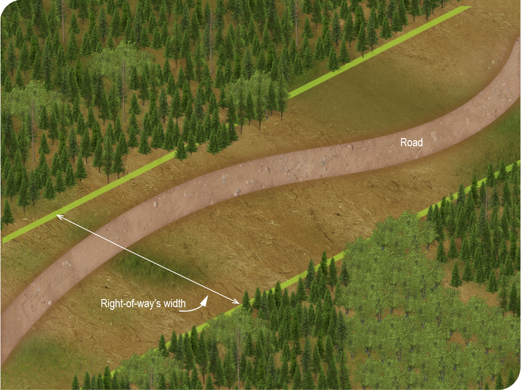
Figure 2E Right-of-way deforestation
“riparian ecotone” means the transitional zone between the water environment and the forest, characterized by the muscinal, herbaceous or shrubby vegetation of wetlands and sometimes including a few scattered trees; (écotone riverain)
“road corridor” means a numbered public road appearing on the official map of the Ministère des Transports and located in the bioclimatic domains of the maple or fir forest referred to in Schedule 1, or such a road located in the bioclimatic domain of the spruce-moss forest referred to in that Schedule that links 2 local municipalities or that covers a distance of no more than 50 km from the urban perimeter of a local municipality. That map is the map accessible on the website of the Ministère des Transports. A unnumbered public road giving access to an Indian reserve, to the settlements of Kitcisakik, Hunter’s Point, Pakuashipi, Oujé-Bougoumou and Winneway, to an accommodation centre or a welcome centre in an outfitting operation, a controlled zone or a wildlife sanctuary within the meaning of sections 86, 104 and 111 of the Act respecting the conservation and development of wildlife (chapter C-61.1) is also considered a road corridor; (corridor routier)
25
Explanations
A road corridor is a numbered public road, located in one of the following bioclimatic domains referred to in Schedule 1 to the Regulation:
- the bioclimatic domains of the maple forest;
- the bioclimatic domains of the fir forest;
- the bioclimatic domain of the spruce-moss forest. In this bioclimatic domain, the road must connect two local municipalities or cover a distance of no more than 50 km from the urban perimeter of a local municipality.
These roads are shown on the official road map of Québec .
An unnumbered public road giving access to:
- an Indian reserve;
- the settlements of Kitcisakik, Hunter’s Point, Pakuashipi, Oujé-Bougoumou and Winneway;
- an accommodation centre or a welcome centre to an outfitting operation, a constroled zone or a wildlife sanctuary within the meaning of sections 86, 104 and 111 of the Act respecting the conservation and development of wildlife (chapter C-61.1) ;
is also considered to be a road corridor.
“salt lick” means a salt lick within the meaning of section 1 of the Regulation respecting wildlife habitats ; (vasière)
“sandpit” means an open-air site where unconsolidated substances such as sand, gravel and soil are extracted. Any site to extract unconsolidated substances transported by truck is deemed to be a sandpit for the purposes of this Regulation; (sablière)
26
Additional information
A site to extract unconsolidated substances that is located in whole or in part outside the right-of-way of a road, is considered to be a sandpit for the purposes of the Regulation.
“scenic outlook” means a site developed for the observation of nature; (belvédére)
“swamp” means land subject to seasonal floods or characterized by a soil permanently or temporarily saturated with water and dominated by a ligneous, shrub or arborescent vegetation growing on a mineral soil. The ligneous vegetal covers more than 25% of the marsh’s area. A marsh may either be riparian, that is, adjacent to a lake or watercourse, or isolated; (marécage)
“territorial reference unit” means a development unit or other forest in the domain of the State or a subdivision thereof, forming a single block, measuring less than 100 km2 in the bioclimatic domains of the maple forest, less than 300 km2 in the bioclimatic domains of the fir forest and less than 500 km2 in the bioclimatic domain of the spruce-moss forest. Those bioclimatic domains are shown in Schedule 1. A territorial reference unit overlapping 2 bioclimatic domains is deemed to be part of the bioclimatic domain in which most of the area is found; (unité territoriale de référence)
“thalweg” means the line connecting the deepest points of the bed of a watercourse; (thalweg)
27

Figure 2F Thalweg
“total cutting” means a forest cutting carried out during one or more operations, spread over 10 years or less, that takes once all interventions are carried out more than 80% of the basal area of the species and diameters specified in the sylvicultural prescription of the stand; (coupe totale)
“tourist circuits or roads” means a road corridor recognized as a main interregional access road or as an itinerary proposed on one of the maps in the tourist guides published jointly by the Gouvernement du Québec and the regional tourist associations; (circuits ou routes touristiques)
“trail intended for motorized all-terrain vehicles” means a trail developed and maintained for users of motorized all-terrain vehicles, including snowmobile trails. The trails intended for motorized all-terrain vehicles that are to be protected are those used year after year and indicated in the numeric information layers used for forest planning; (sentier destiné aux véhicules tout terrain motorisés)
“ungroomed road” means a road free of stumps and free in whole or in part of vegetal cover, that has undergone no earth-moving operation besides what is required to fl atten its surface, and whose use is reserved for the harvest and transportation of timber in winter time; (chemin sans mise en forme)
“visual setting” means a part of the landscape visible from a site of interest over 360 degrees at a height of 1.5 m from the ground and whose limits are given by the surrounding topography; (encadrement visuel)
28
Additional information
The visible landscape must be identified from topography alone, without considering vegetation. The visual screen created by vegetation is not permanent: any change to the screen, as a result of windfall for example, would change the boundaries of the visible area. The use of topography to identify the visible landscape ensures that the entire landscape to be protected is included in the visual setting of a given site of interest.
However, a forest strip may provide a visual screen as an obstacle to a site requiring visual setting. In cases where a strip would be used as an obstacle, a request for an exemption to the Regulation under section 40 of the Sustainable Forest Development Act must be filed with the management unit in charge . However, the following conditions must be met:
The strip should be widened to a minimum of 60 m depth.
No partial cuts can be made.
It must be maintained until the cutover areas have a forest cover at least 4 m tall.
“water fowl gathering area” means a water fowl gathering area within the meaning of section 1 of the Regulation respecting wildlife habitats (chapter C-61.1, r. 18); (aire de concentration d’oiseaux aquatiques)
“water intake” means a site subject to the Regulation respecting the quality of drinking water (chapter Q-2, r. 40) that includes a structure to draw water from a watercourse, lake, reservoir or spring and the 60 m strip of woodland surrounding it; (prise d’eau)
“watercourse” means any permanent or intermittent watercourse of a hydrographic system flowing in a bed, excluding the water discharged by the natural draining of the soil; (cours d’eau)
29
Additional information
The waterflow characterization key is used to differentiate an intermittent watercourse from a permanent watercourse or waterflow due to natural drainage.
“white-tailed deer yard” means a white-tailed deer yard within the meaning of section 1 of the Regulation respecting wildlife habitats ; (aire de confinement du cerf de Virginie)
“wilderness campground” means a site established for the sojourn of campers, not supplied with running water or electric power by a private or public distribution network, and offering a lower quantity and quality of the other services; (camping rustique)
“winter road” means a temporary road summarily groomed and developed mainly for harvesting wood in winter; (chemin d’hiver)
30
Additional information
Winter roads are created mainly to harvest wood and transport it out of the forest in winter. However, they may also be created to allow for other activities, such as snowmobiling.
Winter road construction is fairly rudimentary. The road may or may not be groomed. Grooming may be continuous. The route can be cleared of stumps, partially or fully stripped of its vegetation cover, and levelled without any other earthwork, or simply created from mixing organic and non-organic material with snow. Winter roads are unditched, and only support heavy hauling (for example, of timber or forestry machines) during the winter months. Outside that period, they do not have the carrying capacity for heavy loads. The ad hoc removal of materials from the right-of-way is not considered a ditch as it does not manage the waters from the road within the right-of-way.
Winter roads can be used in other seasons, provided the soil’s carrying capacity is sufficient to allow vehicle traffic without causing ruts. For example, they can be used for forest development activities such as intervention inventories or sylvicultural treatments, or for mineral exploration.
It is forbidden to build a bridge or a culvert on a winter road. Therefore, a roadway built in winter that includes bridges or culverts is not considered a winter road and must be usable during the summer. The road must be usable for all kinds of vehicles likely to take the class of road to which the road belongs.
“wooden culvert” means a culvert with a wooden arch; (ponceau de bois)
“work to build a road, bridge or culvert” means work performed to build a road or road segment at a new place, including work to build bridges and culverts on that road; (travaux de construction d’un chemin, d’un pont ou d’un ponceau)
31
Additional information
As indicated in the work type definitions, the condition of the road prior to the work is the reference for determining the type of work being performed. Road building work is all types of work required to build a road at a location where no road existed, including building structures to cross watercourses. Occasionally, the term “reconstruction” of a bridge or culvert is used. This type of work, as defined by the Regulation, is considered repair or improvement work on a road, depending on the condition of the structure before and after the work.
Section 41 of the Sustainable Forest Development Act states that a person who intends to carry out work for the construction, improvement or decommissioning of a multi-purpose road must be authorized by the Minister on the conditions determined by the Minister. When issuing the authorization, the Minister states which forest development activities are permitted and sets the conditions to be met when they are carried out.
“work to close a road” means work to prevent access to a road or road segment on a permanent or temporary basis. (travaux de fermeture d’un chemin)
32
Additional information
The Sustainable Forest Development Act states that a person who intends to carry out work for the construction, improvement or decommissioning of a multi-purpose road must be authorized by the Minister on the conditions determined by the Minister. When issuing the authorization, the Minister states which forest development activities are permitted and sets the conditions to be met when they are carried out.
For the purposes of this Regulation, an outdoor recreation centre, a scenic outlook, a developed campground, a wilderness campground, an ecological or nature interpretation centre, a cottage that offers lodging and operated on a commercial basis by the manager of an outfitting operation, a controlled zone or a wildlife sanctuary, an outlying circuit of a concentrated network of hiking trails, an accommodation centre, a rest area, a landfill, an observatory, an interregional trail, a public beach, a reception station, a water intake, a concentrated network of hiking trails, a trail intended for motorized all-terrain vehicles, a dock site with a boat ramp, a restaurant or accommodation site, a vacation site, a downhill skiing station and a fish hatchery are those for which a right has been granted under a law or regulation of the Government.
33
Additional information
These particular places and territories are usually shown in the Public Land Use Plan or are the subject of a lease or right of occupation under the Act respecting the lands in the domain of the State .